









Short answer: Jacksonville is the consolidated city government of Duval County, home to an estimated 977,670 people with a median age of 36.5 (ACS 2020-2024 5-year). Mayor Donna Deegan and a 19-member City Council run it from City Hall at St. James, 117 W. Duval Street, and MyJax answers at (904) 630-CITY. JaxReady lists hurricane evacuation zones A through F.
Last verified: October 14, 2026, against the sources listed at the end of this page.
Where is Jacksonville, Florida, and how do people get there?
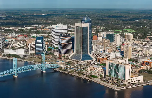
Jacksonville, the consolidated city of Duval County, has 747.266 square miles of land and 127.193 square miles of water inside the city limits.
Those figures come from the Census Bureau's 2024 place gazetteer for Jacksonville city (Census gazetteer). The size follows from consolidation: the city's own website is titled the official City of Jacksonville and Duval County government website (City of Jacksonville), and the city merged with county government in 1968. Land and water together come to 874.459 square miles in the gazetteer.
Air travelers use Jacksonville International Airport (JAX). The airport site lists route news such as Southwest Airlines nonstop service from JAX to Austin, Texas, announced to start on October 2, 2025 (Jacksonville International Airport).
The Jacksonville places section describes neighborhoods from Riverside and San Marco to Mandarin, Arlington and Springfield, and the Jacksonville military section covers Naval Air Station Jacksonville and Mayport.
How many people live in Jacksonville, and who lives there?
Jacksonville had an estimated 977,670 residents with a median age of 36.5 in the Census Bureau's American Community Survey (ACS) 2020-2024 5-year estimates.
In that ACS release, 22.6 percent of Jacksonville residents were under 18 and 14.9 percent were 65 or older (ACS 2024 DP05 table for Jacksonville). Median household income was $69,872, and Jacksonville workers averaged a 24.1 minute trip to work (ACS 2024 DP03 table for Jacksonville).
Most Jacksonville households own: 57.6 percent of occupied homes were owner occupied and 42.4 percent were rented (ACS 2024 DP04 table for Jacksonville). The city counted 430,825 housing units, 394,370 of them occupied. The median value of an owner-occupied Jacksonville home was $293,700, and median gross rent was $1,465 a month.
| Measure | Jacksonville estimate |
|---|---|
| Population | 977,670 |
| Median age | 36.5 |
| Under 18 | 22.6 percent |
| 65 and older | 14.9 percent |
| Median household income | $69,872 |
| Mean travel time to work | 24.1 minutes |
| Housing units | 430,825 |
| Owner occupied | 57.6 percent |
| Median home value (owner occupied) | $293,700 |
| Median gross rent | $1,465 |
These are five-year Jacksonville averages for 2020 through 2024, each with a margin of error in the Census tables. The Jacksonville demographics and real estate sections break the figures down further.
Who runs Jacksonville, and how is City Hall reached?
Mayor Donna Deegan heads Jacksonville's consolidated government, and a 19-member Jacksonville City Council, led as of October 2026 by President Nick Howland, passes city law at City Hall at St. James, 117 West Duval Street.
Deegan is the 45th mayor of the City of Jacksonville and the 9th since consolidation in 1968. She was elected on May 16, 2023, and sworn into office on July 1, 2023 (About the Mayor).
The council's 19 members serve four-year terms as part-time legislators. Jacksonville is divided into 14 districts of nearly equal population, each electing one member, and five more members represent the whole city at large; each May the council elects a president and vice president for one-year terms that begin July 1 (City of Jacksonville). As of October 2026, Nick Howland (At-Large, Group 3) is president, phone (904) 255-5217, and Joe Carlucci (District 5) is vice president (City Council members).
The full council meets on the second and fourth Tuesdays of each month at 5:00 p.m. in the Council Chamber at City Hall at St. James, and meetings air live on Comcast and U-verse channel 99 (council FAQ). The main council number, (904) 255-5200, will match a Jacksonville home address to its district member. For city services, MyJax answers at (904) 630-CITY (2489). Last verified: October 14, 2026, on the City of Jacksonville website.
Jacksonville voters have a county election coming: the Duval County Supervisor of Elections lists the 2026 General Election on November 3, 2026, with early voting from October 20 through November 1 (Duval County Supervisor of Elections). The Jacksonville government section covers the council districts, the budget, property taxes and the Jacksonville Transportation Authority.
What is there to do in Jacksonville?
Jacksonville's biggest draws are its outdoor ones: the Timucuan Ecological and Historic Preserve, with Fort Caroline and Kingsley Plantation, and Kathryn Abbey Hanna Park, with 1.5 miles of sandy beach.
The National Park Service opens the grounds of Fort Caroline National Memorial and Kingsley Plantation from 9:00 a.m. to 5:00 p.m., Wednesday through Sunday, and closes them on Thanksgiving, December 25 and January 1 (Timucuan Preserve hours). Kingsley Plantation charges no admission. Both Jacksonville sites are closed Monday and Tuesday, so a weekday visit needs planning.
Kathryn Abbey Hanna Park, at 500 Wonderwood Drive, charges $5 per car for up to six people and $3 per pedestrian or bicyclist from 8 a.m. to close (Kathryn Abbey Hanna Park). The Jacksonville park has 1.5 miles of beach, including the surfing spot known as The Poles, more than 20 miles of trails, and a 60-acre lake open to fishing and paddling, where swimming is prohibited. Early bird entry from 6 to 8 a.m. requires a ticket, and an annual pass is $92.52 plus tax.
The Jacksonville parks, landmarks, recreation, events and sports sections have their own guides, from the St. Johns River and the Riverwalk to Friendship Fountain, the Cummer Museum, Jaguars games and the city's beaches.
What is changing in Jacksonville in 2026?
The most immediate change for Jacksonville households in October 2026 is the Phase III Extreme Water Shortage, which limits lawn watering in Jacksonville to one day a week.
The St. Johns River Water Management District issued the declaration after prolonged dry conditions, declining groundwater and reduced river flows, and it bars landscape irrigation between 8 a.m. and 6 p.m. (St. Johns River Water Management District). The district says most of the shortage area needs at least 3 feet of rainfall over the next 3 months to return to normal. In Jacksonville, odd-numbered or no-address homes may water on Saturday, even-numbered homes on Sunday, and nonresidential properties on Tuesday (City of Jacksonville).
The Duval County burn ban has been lifted, but that does not make yard fires legal: under Jacksonville Municipal Code Section 420.201, outdoor open burning in Duval County is prohibited year-round without a permit, and the Environmental Quality Division answers permit questions at (904) 255-7100 (City of Jacksonville). The city also reported on October 7, 2026, that its Emergency Preparedness Division was monitoring a nor'easter affecting Duval County.
The Jacksonville environment and utilities sections cover the St. Johns River watershed, water quality, water service and the JEA power plants.
What should Jacksonville residents know about hurricanes and flooding?
Jacksonville uses lettered evacuation zones, A through F, published on JaxReady, where a Duval County address can be checked against the zone map.
Zone A is the most vulnerable and is evacuated first, along with manufactured and mobile homes, and orders move from B to E as storm effects intensify (JaxReady evacuation zones). Zone F is different: it covers areas likely to flood from rainfall or other hazards. JaxReady explains that the interaction of river systems with the Atlantic Ocean makes Jacksonville zones more complex than those in most counties, and that most of Duval County's low-lying areas lie along the coast and rivers.
Flood insurance in Jacksonville carries a discount. FEMA lists the City of Jacksonville (community 120077) in the National Flood Insurance Program at Community Rating System class 6 since May 1, 2010, worth 20 percent off premiums in the special flood hazard area and 10 percent outside (FEMA NFIP community status). The Jacksonville flood maps in effect date from November 2, 2018.
The Jacksonville safety and weather sections cover flood risk zones, hurricane evacuation zones, the hurricane season and past storms such as Hurricane Dora in 1964.
Which Jacksonville guide answers which question?
Each Jacksonville section goes deeper than this profile, and the table below maps common Jacksonville questions to the key fact and the section that answers it.
| Question | Key fact | Jacksonville section |
|---|---|---|
| How big is Jacksonville? | 747.266 sq mi of land, 127.193 of water (2024 gazetteer) | Places |
| How many people live in Jacksonville? | 977,670, median age 36.5 (ACS 2020-2024) | Demographics |
| What does a Jacksonville home cost? | Median owner-occupied value $293,700; median rent $1,465 | Real estate |
| Who is mayor of Jacksonville? | Donna Deegan, sworn in July 1, 2023 | Government |
| When does City Council meet? | 2nd and 4th Tuesdays, 5:00 p.m., 117 W. Duval Street | Government |
| When can Jacksonville lawns be watered? | One day a week under the Phase III water shortage | Utilities and environment |
| How are evacuation zones lettered? | A through F; Zone F is rainfall flooding | Safety |
| What is the flood insurance discount? | CRS class 6, 20 percent in the flood zone | Safety |
Jacksonville also has sections on schools, healthcare, the economy and industries, history, wildlife and weather, each with its own guides.
Frequently asked questions
What county is Jacksonville, Florida in?
Jacksonville is in Duval County, and since 1968 the City of Jacksonville and Duval County have shared one consolidated government. Mayor Donna Deegan is the 9th mayor since that consolidation, and the city website serves as the official Duval County government site.
What is the population of Jacksonville, FL?
The Census Bureau ACS 2020-2024 5-year estimates put Jacksonville at 977,670 residents with a median age of 36.5. About 22.6 percent of Jacksonville residents are under 18, and 57.6 percent of occupied homes are owner occupied.
How many members are on the Jacksonville City Council?
The Jacksonville City Council has 19 members serving four-year terms: 14 elected from districts of nearly equal population and five elected at large. As of October 2026 Nick Howland is council president, and the full council meets on the second and fourth Tuesdays at 5:00 p.m.
What day can Jacksonville residents water their lawns?
Under the Phase III Extreme Water Shortage, odd-numbered or no-address Jacksonville homes may water on Saturday, even-numbered homes on Sunday, and nonresidential properties on Tuesday. Landscape irrigation is prohibited between 8 a.m. and 6 p.m. every day.
How do Jacksonville residents find their evacuation zone?
JaxReady, run by the city Emergency Preparedness Division, has a lookup that finds the evacuation zone for any Duval County address. Zones run from A, evacuated first, through E, and Zone F marks areas likely to flood from rainfall.
Sources
- ACS 2020-2024 5-year DP05, Jacksonville city, Florida (U.S. Census Bureau) https://data.census.gov/api/access/data/table?id=ACSDP5Y2024.DP05&g=160XX00US1235000 Used for: population, median age, age shares
- ACS 2020-2024 5-year DP03, Jacksonville city, Florida (U.S. Census Bureau) https://data.census.gov/api/access/data/table?id=ACSDP5Y2024.DP03&g=160XX00US1235000 Used for: median household income, commute time
- ACS 2020-2024 5-year DP04, Jacksonville city, Florida (U.S. Census Bureau) https://data.census.gov/api/access/data/table?id=ACSDP5Y2024.DP04&g=160XX00US1235000 Used for: housing units, tenure, home value, rent
- 2024 Census Gazetteer, Florida places https://www2.census.gov/geo/docs/maps-data/data/gazetteer/2024_Gazetteer/2024_gaz_place_12.txt Used for: land and water area of Jacksonville city
- City of Jacksonville home page https://www.jacksonville.gov/ Used for: MyJax phone, City Hall address, council structure, water shortage and burn rules, JaxReady
- City Council Members, City of Jacksonville https://www.jacksonville.gov/city-council/city-council-members Used for: council president and vice president, phones
- City Council Frequently Asked Questions, City of Jacksonville https://www.jacksonville.gov/city-council/frequently-asked-questions Used for: meeting schedule and place, main council number, elections office phone
- About the Mayor, City of Jacksonville https://www.jacksonville.gov/mayor/about-the-mayor Used for: Mayor Donna Deegan, 45th mayor, consolidation 1968, election and swearing-in dates
- Duval County Supervisor of Elections https://www.duvalelections.gov/ Used for: 2026 General Election date, early voting dates
- Operating Hours and Seasons, Timucuan Ecological and Historic Preserve (NPS) https://www.nps.gov/timu/planyourvisit/hours.htm Used for: Fort Caroline and Kingsley Plantation hours, admission
- Kathryn Abbey Hanna Park, City of Jacksonville https://www.jacksonville.gov/departments/parks-and-recreation/jaxparks/oceanfront-parks/kathryn-abbey-hanna-park Used for: address, fees, beach, trails, lake
- JaxReady Evacuation Zones, City of Jacksonville https://www.jaxready.com/Alerts/Evacuation-Zones Used for: evacuation zones A to F, Zone F flooding
- Water Shortage, St. Johns River Water Management District https://www.sjrwmd.com/water-conservation/water-shortage/ Used for: Phase III Extreme Water Shortage restrictions
- NFIP Community Status Book record for City of Jacksonville (FEMA OpenFEMA) https://www.fema.gov/api/open/v1/NfipCommunityStatusBook?$filter=communityIdNumber%20eq%20%27120077%27 Used for: CRS class, discounts, flood map date
- Jacksonville International Airport (Jacksonville Aviation Authority) https://www.flyjax.com/ Used for: airport and new nonstop routes
How this page was made
Digital Towns uses AI assistance to research and write its guides, and every page is only as good as the sources it cites. Our goal is the most accurate, useful local information possible.
This page was fact-checked twice before publishing.
If you see an error, or anything you can show is false, tell us right away and we will take a third look.
Report an error
Thank you. We'll take a third look and correct the page if it's wrong.

