













Short answer: Miami is a Miami-Dade County city of about 459,745 people (ACS 2020-2024 5-year) on Biscayne Bay, served by Miami International Airport and the 25-mile Metrorail. Mayor Eileen Higgins, five district commissioners and City Manager James Reyes run it; the Commission meets at Miami City Hall, 3500 Pan American Drive, and services answer at 311 or 305-468-5900. FEMA lists new City of Miami flood maps for February 19, 2027.
Last verified: October 15, 2026, against the sources listed at the end of this page.
Where is Miami, Florida, and how is it reached?
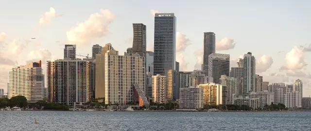
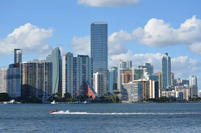
Miami is a Miami-Dade County city on Biscayne Bay with 35.996 square miles of land and 20.077 square miles of water, reached by air through Miami International Airport and by Metrorail.
Water is a big part of the map. The Census Bureau 2024 gazetteer lists the City of Miami with 35.996 square miles of land and 20.077 square miles of water (Census gazetteer), which is why Biscayne Bay, the Miami River and Virginia Key shape so much of daily life in the city.
Miami International Airport (MIA) sits on 3,230 acres near downtown Miami and is owned by Miami-Dade County and run by the Miami-Dade Aviation Department (Miami International Airport). MIA was founded in 1928 and handled 55,314,661 passengers in 2025, 24,850,064 of them international. In August 2026 the airport listed 92 carriers.
Metrorail is the rail link. The Miami-Dade system is a 25-mile dual track that runs from Kendall through South Miami, Coral Gables and downtown Miami to Hialeah, and it operates from 5 a.m. to midnight, seven days a week (Miami-Dade Metrorail). The Green Line runs between Palmetto and Dadeland South. On weekends the Orange Line runs only as an airport shuttle between Earlington Heights and the MIA station every 15 minutes, so a weekend airport trip from downtown Miami means a transfer at Earlington Heights. Metrorail fare gates do not accept cash.
The Miami transportation section goes deeper in its Metrorail and Metromover, Miami International Airport and PortMiami guides.
How many people live in Miami, and who lives there?
Miami had an estimated 459,745 residents with a median age of 39.3 in the Census Bureau American Community Survey (ACS) 2020-2024 5-year estimates (ACS DP05 table for Miami).
Miami is majority Hispanic and majority foreign born. In the same ACS 2020-2024 release, 71.5 percent of Miami residents were Hispanic or Latino of any race (ACS DP05), and 57.7 percent were born outside the United States (ACS DP02 table for Miami). Among Miami adults 25 and over, 37.4 percent held a bachelor degree or higher. Only 15.9 percent of residents were 65 or older.
Miami is a city of renters. Just 30.8 percent of occupied Miami homes were owner occupied, the median owner-occupied home value was $518,100, and median gross rent was $1,758 a month (ACS DP04 table for Miami). Median household income was $62,462 and workers averaged 27.3 minutes to get to work (ACS DP03 table for Miami).
| Measure | Miami city |
|---|---|
| Population | 459,745 |
| Median age | 39.3 |
| Residents 65 and older | 15.9 percent |
| Hispanic or Latino (any race) | 71.5 percent |
| Foreign born | 57.7 percent |
| Bachelor degree or higher (25 and over) | 37.4 percent |
| Median household income | $62,462 |
| Mean travel time to work | 27.3 minutes |
| Housing units | 223,826 |
| Occupied housing units | 194,821 |
| Owner-occupied homes | 30.8 percent |
| Median home value (owner occupied) | $518,100 |
| Median gross rent | $1,758 |
Each Miami figure is a five-year ACS average for 2020 through 2024 with its own margin of error, not a single-year count. The Miami history section explains how much of this came to be, with guides on the Cuban exile community, the Freedom Flights of 1965 to 1973 and the Mariel boatlift, and the real estate section covers Miami neighborhoods, Brickell condos and market trends.
Who runs Miami, and how is Miami City Hall reached?
Mayor Eileen Higgins and five district commissioners lead the City of Miami, City Manager James Reyes runs daily operations, and the Miami City Commission meets at 9 a.m. at Miami City Hall, 3500 Pan American Drive.
The city site lists the five Miami commissioners by district: Miguel Angel Gabela (District 1), Damian Pardo (District 2), Rolando Escalona (District 3), Ralph Rafael Rosado (District 4) and Christine King (District 5) (City of Miami). City Clerk Todd B. Hannon keeps the record, and George Wysong is City Attorney.
All City of Miami Commission meetings take place at 9:00 a.m. at City Hall, 3500 Pan American Drive, Miami 33133, and the remaining 2026 dates are October 22, November 19 and December 10 (City Commission Meetings 2026). Meetings can be watched live on City of Miami TV.
Miami City Hall is where the Commission meets. The miami.gov footer lists the Miami Riverside Center (MRC), 444 SW 2nd Ave, as the contact address, and residents reach city services by dialing 311 or 305-468-5900 (miami.gov contact). A practical tip: a permit, payment or service question usually starts with Miami 311 or the Riverside Center, not City Hall.
Many services, from Metrorail to the airport and countywide emergency management, belong to Miami-Dade County rather than the city. Last verified: October 15, 2026, on the City of Miami website. The Miami government section covers the officials, commission members, meetings and budget in depth, and the civic engagement section explains the City Council, neighborhood associations and voting precincts.
What is there to do in Miami?
Miami life runs outdoors: the City of Miami runs over 150 parks totaling more than 1,400 acres, and downtown has two free parks on Biscayne Bay.
The City of Miami Parks and Recreation Department lists 12 swimming pool facilities, 43 community centers, 4 gymnasiums, a Japanese Garden, the Grapeland Water Park and the Little Haiti Cultural Center and Caribbean Marketplace (Miami Parks and Recreation). On Virginia Key the department offers mountain bike trails, walking trails and beaches, and its Ocean Rescue section is based at Virginia Key Beach.
Bayfront Park, 301 Biscayne Blvd, is a 32-acre waterfront park open daily 7 a.m. to 11 p.m., and Maurice A. Ferre Park, 1075 Biscayne Blvd, is a 30-acre park open daily 7 a.m. to 10 p.m. (Bayfront Park Management Trust). Both downtown Miami parks have free admission, 365 days a year. On the water, the city runs Dinner Key Marina, Miamarina at Bayside and Marine Stadium Marina (Miami Parks and Public Places).
One small discrepancy on the city site: the Miami Parks and Public Places page says Miami is home to over 147 parks, gardens, recreation areas and playgrounds (Parks and Public Places page), while the Parks and Recreation Department page says over 150 parks. Either way, the park directory on miami.gov is the place to check a specific Miami park before going.
The Miami landmarks section has guides to Vizcaya Museum and Gardens, the Freedom Tower, Wynwood Walls, Coral Castle and Jungle Island; the parks section covers Biscayne National Park; the recreation section covers Miami beaches, boating and fishing; and the sports section covers the Miami Heat, Miami Marlins, Inter Miami CF, Miami Dolphins and the University of Miami.
What is changing in Miami in 2026?
In fall 2026 Miami is setting a new city budget, planning the Miami Loop, rerouting two Biscayne Trolley routes, and facing new FEMA flood maps that the federal record lists for February 19, 2027.
Under Resolution R-26-0320, adopted on July 23, 2026, the Miami City Commission set its first budget hearing for September 10, 2026 and its second for September 24, 2026, both at 5:05 p.m. at Miami City Hall (City of Miami notices). A Sunshine notice published September 29, 2026 said two or more Miami commissioners might attend a Miami Loop Summit on how the pieces of the Miami Loop are coming together and what comes next.
Transit riders should know that the Biscayne Trolley Brickell and Coconut Grove routes have been on detour since September 23, 2026, until further notice (miami.gov trolley notice). In Allapattah, Sunshine notices from September 23, 2026 announced community meetings on the status of the Allapattah Redevelopment District Community Redevelopment Agency.
Flood maps are the change most Miami property owners will feel. FEMA Community Status Book data for the City of Miami, refreshed October 14, 2026, lists a map date of 02/19/27 (FEMA NFIP record for Miami). The Miami-Dade County preliminary map FAQ has not caught up: it still says the last maps took effect on September 11, 2009 and that the new preliminary maps could become effective as early as March 1, 2022 (Miami-Dade FEMA map FAQ). Checking a Miami address against the new maps before February 2027 avoids an insurance surprise.
The Miami future section and the real estate section, with its new construction 2026 and luxury condos 2026 guides, track what is being built, and the economy section covers downtown redevelopment.
What should Miami residents know about hurricanes and flooding?
Miami hurricane planning runs through two offices: the City of Miami Division of Emergency Management (305-416-5439, text ALERTMIAMI to 888777) and Miami-Dade County Emergency Management, which publishes the Storm Surge Planning Zones.
The City of Miami Division of Emergency Management is on the 10th floor of the Miami Riverside Center, 444 SW 2nd Avenue, and its phone is 305-416-5439 (City of Miami Emergency Management). Residents can sign up for city emergency alerts by texting ALERTMIAMI to 888777, and the city posts a hurricane guide on the same page.
Evacuation information comes from the county. Miami-Dade County Emergency Management, at the R. David Paulison Fire Rescue Headquarters, 9300 NW 41st St, phone 305-468-5400, publishes Storm Surge Planning Zones that show which areas could be affected by storm surge (Miami-Dade Emergency Management). Its Emergency and Evacuation Assistance Program (EEAP) provides evacuation help to Miami-Dade residents who need specialized transportation.
On flood insurance, FEMA places the City of Miami (community 120650) in Community Rating System class 6, effective October 1, 2022, worth a 20 percent premium discount inside the special flood hazard area and 10 percent outside it (FEMA NFIP record). The Miami safety section has guides on hurricane evacuation zones, flood risk zones and emergency services, the environment section covers sea-level rise and Biscayne Bay, and the weather section covers Miami storms and seasons.
Which Miami guide answers which question?
Each Miami question on this page has a Digital Towns section that goes deeper, from Metrorail and Miami International Airport to the Miami City Commission and hurricane evacuation zones.
| Question | Key fact | Where to go deeper |
|---|---|---|
| How is Miami reached? | MIA, 3,230 acres; Metrorail, 25 miles, 5 a.m. to midnight | Transportation: Metrorail and Metromover, Miami International Airport, PortMiami |
| Who lives in Miami? | 459,745 residents, median age 39.3 (ACS 2020-2024) | History: Cuban exile community, Freedom Flights, Mariel boatlift |
| Who runs Miami? | Mayor Eileen Higgins, five commissioners, City Manager James Reyes | Government: officials, city council members, meetings, budget |
| Where does the Commission meet? | 9 a.m. at Miami City Hall, 3500 Pan American Drive | Civic engagement: city council, voting precincts |
| What is there to do? | Over 150 city parks; Bayfront Park open 7 a.m. to 11 p.m., free | Landmarks, parks, recreation, sports |
| What about storms? | Text ALERTMIAMI to 888777; county Storm Surge Planning Zones | Safety: hurricane evacuation zones, flood risk zones |
Miami schools are covered in the schools section (public schools, magnet programs, charter schools), Miami wildlife in guides to manatees, sea turtles, dolphins and the American crocodile, and Miami work life in the industries section on finance, cruise tourism, logistics and trade, and tech.
Frequently asked questions
What county is Miami, Florida in?
Miami is in Miami-Dade County. The county, not the City of Miami, runs Miami International Airport, Metrorail and countywide emergency management, while the city runs its own commission, parks, marinas and a Division of Emergency Management at the Miami Riverside Center.
What is the population of Miami, Florida?
The Census Bureau ACS 2020-2024 5-year estimates put the City of Miami at 459,745 residents, with a median age of 39.3. In that survey 71.5 percent of residents were Hispanic or Latino and 57.7 percent were born outside the United States.
Who is the mayor of Miami?
Eileen Higgins is listed as Mayor of the City of Miami on miami.gov in October 2026. Five district commissioners, Miguel Angel Gabela, Damian Pardo, Rolando Escalona, Ralph Rafael Rosado and Christine King, sit on the City Commission, and James Reyes is City Manager.
Where is Miami City Hall and how are city services reached?
Miami City Hall is at 3500 Pan American Drive, Miami 33133, where the City Commission meets at 9 a.m. For services, the city lists 311 or 305-468-5900 and the Miami Riverside Center at 444 SW 2nd Ave as its contact address.
How do Miami residents get emergency alerts?
The City of Miami sends emergency alerts to residents who text ALERTMIAMI to 888777. The city Division of Emergency Management answers at 305-416-5439, and Miami-Dade County Emergency Management, 305-468-5400, publishes the Storm Surge Planning Zones used for evacuations.
Sources
- City of Miami home page (miami.gov) https://www.miami.gov/Home Used for: mayor, commissioners, City Manager, 311 line, Miami Riverside Center, 2026 commission and budget hearing notices, Miami Loop summit, trolley detour
- City Commission Meetings 2026, City of Miami https://www.miami.gov/My-Government/Departments/Planning/Planning-Calendar-of-Meetings-Events/City-Commission-Meetings-2026 Used for: meeting time and place at Miami City Hall, remaining 2026 dates
- Division of Emergency Management, City of Miami https://www.miami.gov/My-Government/Departments/Emergency-Management Used for: city emergency office address, phone, ALERTMIAMI text alerts
- Parks and Recreation Department, City of Miami https://www.miami.gov/My-Government/Departments/Parks-and-Recreation Used for: park count, acreage, pools, community centers, Virginia Key
- Parks and Public Places, City of Miami https://www.miami.gov/Parks-Public-Places Used for: second park count, Dinner Key Marina
- Bayfront Park Management Trust https://www.bayfrontparkmiami.com/ Used for: Bayfront Park and Maurice A. Ferre Park addresses, acreage, hours, free admission
- Miami-Dade County Emergency Management https://www.miamidade.gov/global/emergency/home.page Used for: county emergency office address and phone, Storm Surge Planning Zones, EEAP
- FEMA Preliminary Flood Zone Maps FAQ, Miami-Dade County https://www.miamidade.gov/global/economy/building/flood-protection/fema-maps.page Used for: last effective map date and stale preliminary map date
- FEMA NFIP Community Status Book, City of Miami (community 120650) https://www.fema.gov/api/open/v1/NfipCommunityStatusBook?$filter=communityIdNumber%20eq%20%27120650%27 Used for: CRS class, premium discounts, listed map date
- Metrorail, Miami-Dade County Department of Transportation and Public Works https://www.miamidade.gov/global/transportation/metrorail.page Used for: Metrorail length, hours, lines, MIA connection
- About MIA, Miami International Airport https://www.miami-airport.com/about_us.asp Used for: airport size, founding year, 2025 passengers, carriers
- U.S. Census Bureau 2024 Gazetteer, Florida places https://www2.census.gov/geo/docs/maps-data/data/gazetteer/2024_Gazetteer/2024_gaz_place_12.txt Used for: land and water area of Miami city
- ACS 2020-2024 5-year DP05, Miami city, Florida (U.S. Census Bureau) https://data.census.gov/api/access/data/table?id=ACSDP5Y2024.DP05&g=160XX00US1245000 Used for: population, median age, 65 and older, Hispanic or Latino share
- ACS 2020-2024 5-year DP03, Miami city, Florida (U.S. Census Bureau) https://data.census.gov/api/access/data/table?id=ACSDP5Y2024.DP03&g=160XX00US1245000 Used for: median household income, commute time
- ACS 2020-2024 5-year DP04, Miami city, Florida (U.S. Census Bureau) https://data.census.gov/api/access/data/table?id=ACSDP5Y2024.DP04&g=160XX00US1245000 Used for: housing units, occupancy, owner share, home value, rent
- ACS 2020-2024 5-year DP02, Miami city, Florida (U.S. Census Bureau) https://data.census.gov/api/access/data/table?id=ACSDP5Y2024.DP02&g=160XX00US1245000 Used for: foreign-born share, bachelor degree share
How this page was made
Digital Towns uses AI assistance to research and write its guides, and every page is only as good as the sources it cites. Our goal is the most accurate, useful local information possible.
This page was fact-checked twice before publishing.
If you see an error, or anything you can show is false, tell us right away and we will take a third look.
Report an error
Thank you. We'll take a third look and correct the page if it's wrong.

